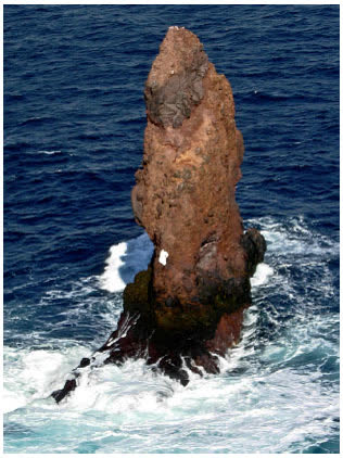
Deception Island “Kraken” → Sail Rock
A Google Earth “sea monster” off Deception Island matches Sail Rock on nautical charts — explained geospatial candidate.
Sources Long Island Press (20 Jun 2016); contemporary chart references (NOAA/UKHO where public); Wikimedia Sail Rock geography
A Google Earth anomaly off Deception Island in the South Shetlands circulated online as a “Kraken.” Nautical charts and local knowledge identify the feature as Sail Rock — a named rock, not a cephalopod.
Event dating note
The viral press cycle is historically 2016; this ledger files it under a 2026-06-16 topic-lesson slot for archive chronology, not as a new 2026 discovery. Same pixel habit as Loch Ness reports: chart first, monster second.
Status hoax (explained candidate): the monster reading collapses under chart geography. Pair with an open IR file for status grammar.
Evidence ledger
Each claim in this file, the source it rests on, and how well it holds up: 1 corroborated · 2 debunked. What the labels mean.
| Claim | Source | Type · date | Status |
|---|---|---|---|
| A Google Earth feature off Deception Island went viral as a ‘Kraken.’ | Long Island Press | press · 20 Jun 2016 | corroborated |
| The feature is a sea creature.Charts identify it as Sail Rock. | Nautical chart references (NOAA/UKHO where public); Sail Rock geography | official | debunked |
| The viral story is a 2026 event.Filed under a 2026 topic slot for chronology only. | Long Island Press (2016) | press · 2016 | debunked |
Discussion
Discussions activating. Per-case threads will embed here once the Giscus GitHub App is installed on the public satellite repo.
Meanwhile, join the conversation on GitHub Discussions: https://github.com/dclewis21/anomaly-ledger-community/discussions
CoS / D.C.: see Community guidelines and
SETUP.mdin the site repo for the one-click Giscus install.