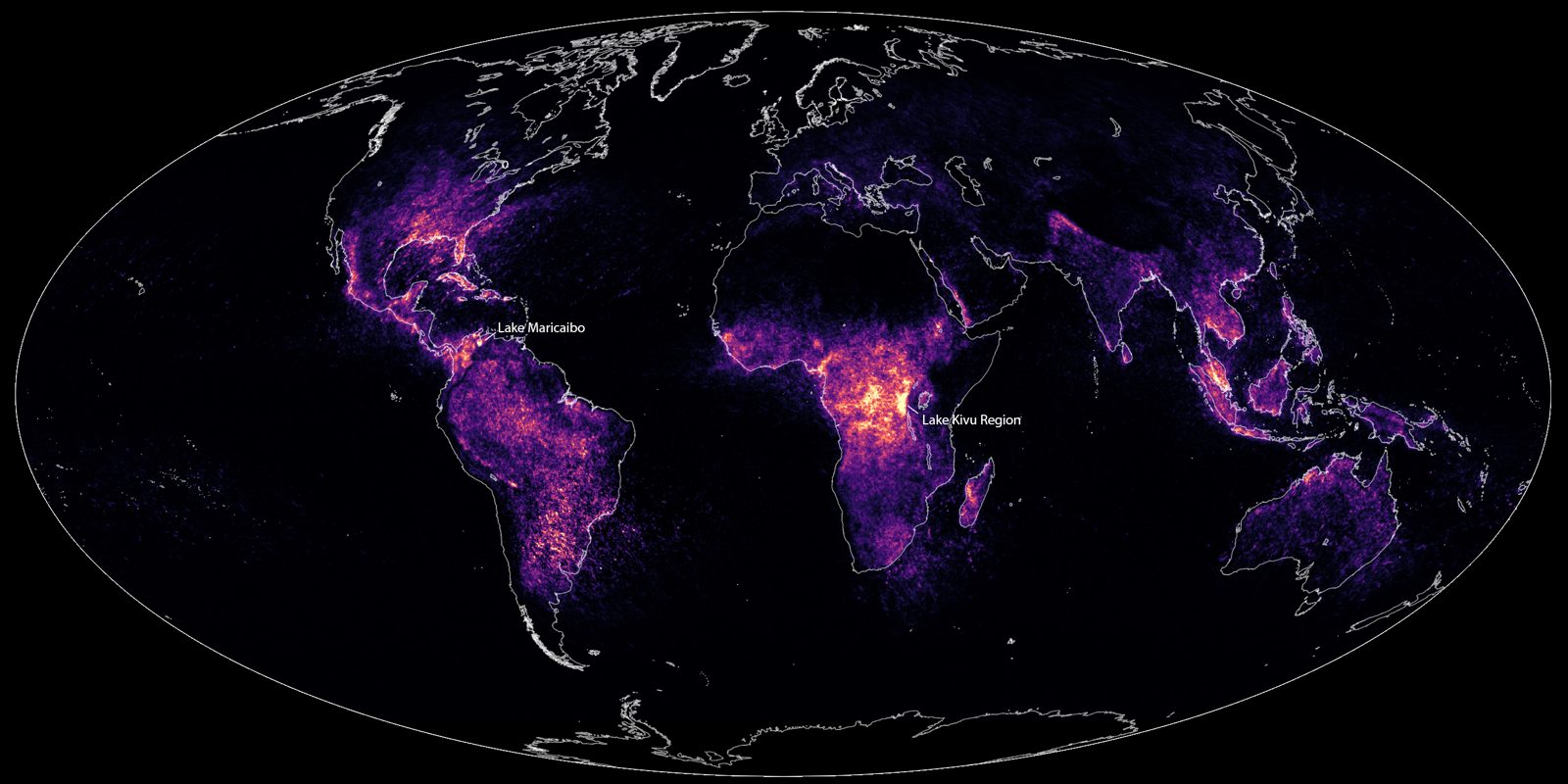
The evidence: World map of lightning frequency from NASA space sensors, with Lake Maracaibo labeled as the brightest spot in the Americas
The Catatumbo Lightning: Why One Venezuelan Lake Lights Up Almost Every Night
Last reviewed Next review
We review and update every article weekly. When the record changes, so does the article. How we review
Over one corner of Lake Maracaibo, storms flash nearly every night of the year. Satellites now rank it Earth's top lightning spot. Here is why it happens.
Verdict: The Catatumbo lightning is real and well measured: it is ordinary thunderstorm lightning, made unusually frequent by the lake's warm water and the winds funneled in by the mountains around it, with no need for the old methane theory.
Original sources: Rachel I. Albrecht et al., 'Where Are the Lightning Hotspots on Earth?', Bulletin of the American Meteorological Society 97:11 (2016), full text at the NOAA library · Rodrigo E. Bürgesser, María G. Nicora and Eldo E. Ávila, 'Characterization of the lightning activity of Relámpago del Catatumbo', Journal of Atmospheric and Solar-Terrestrial Physics (2012) · NASA, 'Earth's New Lightning Capital Revealed' (2 May 2016) · Yolanda Valery, '"Desaparece" relámpago del Catatumbo', BBC Mundo (4 March 2010, in Spanish) · 'Drought extinguishes Venezuela's lightning phenomenon', The Guardian (5 March 2010)
Sources R. I. Albrecht et al., Bulletin of the American Meteorological Society 97:11 (2016); R. E. Bürgesser, M. G. Nicora and E. E. Ávila, Journal of Atmospheric and Solar-Terrestrial Physics (2012); NASA (2016); BBC Mundo (4 March 2010, in Spanish); The Guardian (5 March 2010)
In northwestern Venezuela, where the Catatumbo River runs into the southwest corner of Lake Maracaibo, the night sky flickers. On most nights of the year, storms build over the water after dark and flash for hours. People in the state of Zulia call it the Relámpago del Catatumbo, the Catatumbo lightning.
For a long time it was treated as a riddle. Was it really lightning, or some other glow? Why there, and why every night? Today we have something earlier writers did not: years of measurements from satellites that count lightning flashes from space. That record, shown at the top of this page, settles the main question. The answer is less mysterious than the legend, but the numbers are remarkable.
An old story
The physicists Rodrigo Bürgesser, María Nicora and Eldo Ávila of Argentina’s national research council, CONICET, open their 2012 study by calling it “the most persistent thunderstorm of the world”, visible almost all year and lasting up to nine hours a night. They write that the Spanish poet Lope de Vega mentioned it in a poem in 1597, telling how the flashes spoiled an attack on Maracaibo by the English privateer Francis Drake, and that the German naturalist Alexander von Humboldt also saw it. BBC Mundo’s 2010 report also points back to Humboldt’s description, and puts the display at seven to ten hours a night, with around 50 discharges a minute at its height.
Those are stories about the lightning, not measurements of it. We report the Drake episode the way the paper does: as something a poet told, not as a documented battle.
What the satellites found
NASA and Japan’s space agency flew a Lightning Imaging Sensor on the TRMM satellite from late 1997 to 2015. It recorded flashes across the tropics, day and night. In 2016 a team led by Rachel Albrecht reprocessed sixteen years of that data on a much finer grid, about ten kilometers to a cell, and published the result in the Bulletin of the American Meteorological Society.
Their finding was that the top lightning hotspot on Earth is not in Africa’s Congo basin, as earlier, coarser maps had suggested, but directly over Lake Maracaibo, at about 9.75° north and 71.65° west. The rate there is about 233 flashes per square kilometer per year. Second place, near Kabare in the Democratic Republic of the Congo, has about 205. The Maracaibo maximum is small: the area with more than 50 flashes per square kilometer per year covers only about 5,500 square kilometers, which is why the older maps missed it. The paper names Lagunillas, on the east side of the lake about 60 kilometers away, as the nearest populated place, and that is the town we use for our map pin rather than the water or the swamps.
The timing is just as striking. Almost no lightning shows up there in the daytime. Activity builds after midnight and peaks around 3 AM local time. Through the year, the busiest months are August to November, with a second, flatter peak in May and June, and almost nothing in January and February. On average, the paper says, storms form over the lake on 297 days a year. NASA’s 2016 summary of the study repeats those figures.
The 2012 study by Bürgesser and his colleagues used a different instrument, the ground-based World Wide Lightning Location Network, and found the same pattern from another angle: two very small centers of activity, one over the southwest of the lake near 9.5° north and 71.5° west and a second near the Colombia and Venezuela border, a strong nighttime cycle, and two seasonal peaks around May and October.
Why there
Both papers point to geography. Lake Maracaibo covers about 13,210 square kilometers, according to Albrecht’s team, and sits in a low basin ringed by mountains on the south, west and east. The water stays very warm all year, 28 to 31 °C. Albrecht’s team ties the night storms to local winds: air moving down off the mountains and across the lake meets over the warm, moist water, is pushed upward, and builds deep thunderstorms in the same place, night after night.
A different idea had been popular: that methane from the swamps around the river mouth feeds the lightning. Bürgesser and his colleagues address it directly. They write that it “does not seem very plausible, since the methane content in the atmosphere is not high enough”, and that many places with more methane in the air have no such lightning. They conclude the activity is a consequence of local winds and weather patterns.
The year it went dark
The lightning is regular, not guaranteed. In early 2010 a severe drought linked to El Niño hit Venezuela. BBC Mundo reported on 4 March 2010 that, according to the Venezuelan environmentalist Erik Quiroga, the lightning had been “missing” since late January, which he called its longest absence in 104 years. The next day The Guardian reported the same: a display that can produce up to 20,000 bolts a night had stopped in late January. Both papers linked the gap to the drought. BBC Mundo also quotes Leonardo Sánchez of the environmental group AZUL saying something similar had happened about five years earlier. That fits the physics: no moisture, no storms, no lightning.
Sources
- Rachel I. Albrecht et al., “Where Are the Lightning Hotspots on Earth?”, Bulletin of the American Meteorological Society 97, no. 11 (2016): full text at the NOAA Institutional Repository (read 30 Oct 2026)
- Rodrigo E. Bürgesser, María G. Nicora and Eldo E. Ávila, “Characterization of the lightning activity of ‘Relámpago del Catatumbo’”, Journal of Atmospheric and Solar-Terrestrial Physics (2012): author copy at the World Wide Lightning Location Network (read 30 Oct 2026)
- NASA, “Earth’s New Lightning Capital Revealed”, 2 May 2016: NASA article (read 30 Oct 2026)
- NASA Scientific Visualization Studio, “A New Look at Earth’s Lightning”, 23 September 2024: map and credits (read 30 Oct 2026)
- Yolanda Valery, “‘Desaparece’ relámpago del Catatumbo”, BBC Mundo, 4 March 2010: article, in Spanish (read 30 Oct 2026; our translation)
- “Drought extinguishes Venezuela’s lightning phenomenon”, The Guardian, 5 March 2010: article (read 30 Oct 2026)
Weighing it
The core of this case is not in doubt. Two independent kinds of instruments, one in orbit and one on the ground, put a small, intense lightning center over the southwest of Lake Maracaibo, mostly at night, most of the year. The explanation the scientists give, warm water plus mountain and lake winds meeting in a closed basin, matches the timing and the location, and the 2010 drought gap fits it too. We mark it explained.
Some popular numbers do not line up, and we would not lean on them. BBC Mundo’s 2010 piece says the storms appear on 140 to 160 nights a year, while the satellite study averages 297 storm days; the difference may come down to what counts as a visible display from shore versus any storm the sensor sees, but neither source says so. Claims that the lightning “regenerates the ozone layer”, repeated in the 2010 coverage, come from environmental advocates quoted in the article, not from the measurement studies we read, so we leave them out of our verdict.
Every image on this page is credited where it appears.
Verdict
Explained The Catatumbo lightning is real and well measured: it is ordinary thunderstorm lightning, made unusually frequent by the lake's warm water and the winds funneled in by the mountains around it, with no need for the old methane theory.
Update log
-
We added this case file.
-
Weekly re-check of sources; no change to the record since filing. Next check November 9, 2026.
Discussion
Discuss this case on the on-site Community board — no GitHub account required. Prefer a private tip for the editorial team? Submit a Sighting.
House rules: Community guidelines.