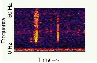
The evidence: Spectrogram and recording of the 1997 Bloop
The Bloop, 1997: The Ocean Sound That Was Ice
Last reviewed Next review
We review and update every article weekly. When the record changes, so does the article. How we review
NOAA hydrophones caught a huge low sound in 1997. NOAA later matched it to cracking icebergs.
Verdict: NOAA's own data match the Bloop to icequakes from large Antarctic icebergs cracking apart, not to an animal.
Original sources: NOAA PMEL, Icequakes (Bloop)
Sources NOAA PMEL Acoustics Monitoring Program, 'Icequakes (Bloop)'
In the summer of 1997, underwater microphones run by NOAA picked up a loud, broad, low-frequency sound that people later nicknamed the Bloop. For years it was a favorite of sea-monster lists, because few things in the ocean are loud enough to cross thousands of kilometers of water.
What NOAA found
NOAA’s Pacific Marine Environmental Laboratory later put hydrophones in the Scotia Sea, near Antarctica. They recorded many icequakes, the sounds of big icebergs cracking and breaking, and their spectrograms looked very much like the Bloop. In early 2008 the team used those icequakes to follow iceberg A53a as it fell apart near South Georgia Island.
Icequakes are loud enough to register on several sensors more than 5,000 km away. Working from the direction the 1997 sound arrived from, NOAA places the source somewhere between Bransfield Strait and the Ross Sea, or possibly at Cape Adare, which NOAA describes as a well-known source of ice sounds.
Hear it yourself
NOAA’s page has the original recording sped up 16 times, alongside recordings of an iceberg calving and of an iceberg grinding on the seabed. Listening to them side by side is the quickest way to see why the agency settled on ice.
Where we land
Explained. The Bloop is a real sound, and the best match in NOAA’s own data is Antarctic ice breaking up.
Sources
- NOAA PMEL Acoustics Monitoring Program, “Icequakes (Bloop)”: pmel.noaa.gov
Every image on this page is credited where it appears.
Verdict
Explained NOAA's own data match the Bloop to icequakes from large Antarctic icebergs cracking apart, not to an animal.
Evidence ledger
Each claim in this file, the source it rests on, and how well it holds up: 4 corroborated · 1 debunked. What the labels mean.
| Claim | Source | Type · date | Status |
|---|---|---|---|
| The broadband sounds recorded in summer 1997 are consistent with icequakes from large cracking icebergs. | NOAA PMEL | official | corroborated |
| Hydrophones in the Scotia Sea recorded many icequakes with spectrograms very like the Bloop, and these tracked iceberg A53a breaking up near South Georgia in early 2008. | NOAA PMEL | official | corroborated |
| Icequakes can be detected on several sensors more than 5,000 km away. | NOAA PMEL | official | corroborated |
| Arrival direction puts the source between Bransfield Strait and the Ross Sea, or possibly Cape Adare. | NOAA PMEL | official | corroborated |
| The Bloop came from a giant unknown animal.NOAA's comparison with known icequakes. | Popular claims | social | debunked |
Update log
-
We added this case file.
-
Weekly re-check of sources; no change to the record since filing. Next check November 9, 2026.
Discussion
Discuss this case on the on-site Community board — no GitHub account required. Prefer a private tip for the editorial team? Submit a Sighting.
House rules: Community guidelines.